Trace the historic route's alignments through the years.
Tracking Route 66 through OKC
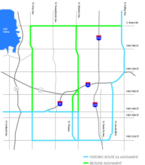
Alignments changed so many times through the years, snaking their way through side streets, neighborhoods, and smaller municipalities that are now a part of Oklahoma City. The following map shows the historic route's alignment and the beltline alignments.
Coming into Oklahoma City: Blue Line.
1926-1954
South on Kelley Avenue to I-44, south on Lincoln Boulevard into the city turning west on 23rd Street.
1954-1979
Beltline 66 alignments: Green Line.
1931-1936
Britton Road to Western Avenue. Western Avenue to 39th Street.
1936-1953
Britton Road to Western Avenue. Western Avenue to Classen Boulevard. Classen Boulevard to 39th Street.
1947-1953
Britton Road to May Avenue.
1953
This beltline was deleted.
City 66 Alignments | West of Oklahoma State Capital: Blue Line.
1926-1930
Along Northwest 23rd Street to Classen Boulevard. Classen Boulevard to 39th Street.
1930-1933
Along Northwest 23rd Street to Western Avenue. Western Avenue to 39th Street.
1933-1954
Along Northwest 23rd Street to May Avenue. May Avenue to 39th Street.
1933-1953
Western Avenue from Northwest 23rd Street to 39th Street. 39th Street west to May Avenue became Alternate 66 Route.
1954-1979
Along Northwest 23rd Street to May Avenue. May Avenue to 39th Street became Business 66 as City 66 was eliminated.
1979
On March 5, 1979, US 66 Business Route deleted in Oklahoma City.